Latest Technical Service
Remote Sensing Technology Service Examples

2021 Haiti Earthquake
Preliminary Results of Differential Interferometric SAR (DInSAR) Processing
Latest Technical Services
Remote Sensing Technology Service Examples
2021 Haiti Earthquake
Preliminary Results of Differential Interferometric SAR (DInSAR) Processing
This is the result of differential interferometric SAR (DInSAR) processing using C-band SAR data from Sentinel-1 satellite operated by the ESA, acquired before and after the earthquake that occurred Haiti on August 14, 2021 (12:29 UTC; M7.2).
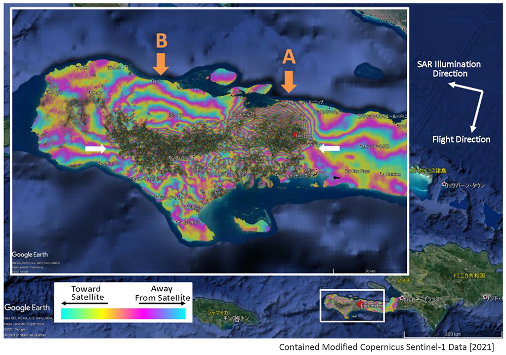
We processed data acquired on August 3 and August 15, 2021, from the southward (descending) orbit. The figure shows the phase of the differential interferogram. Red stars in the figure indicate the epicenter locations provided by the USGS. Sentinel-1 SAR data are C-band (wavelength = 5.6 cm), and one cycle of phase change corresponds to surface displacement of half a wavelength (2.8 cm) in the satellite’s line-of-sight direction. An increase in phase indicates movement away from the satellite, which for the descending orbit corresponds to subsidence, westward displacement, or both. A decrease in phase indicates movement toward the satellite, corresponding to uplift, eastward displacement, or both. Black areas without phase color indicate low coherence, meaning no interferometric signal was detected. Such loss of coherence is considered to result from spatially discontinuous caused by abrupt displacement, indicating the possibility of very large ground deformation such as landslides. The phase pattern reveals a linear low-coherence zone extending east-west (see white arrows in the figure), indicating significant ground displacement along this line. This line coincides with the location of the Enriquillo-Plantain Garden fault running east-west across the peninsula, indicating that the earthquake was associated with activity along this fault. Near the epicenter (marked “A” in the figure), a concentric phase pattern is observed, showing displacement toward the satellite that increases toward the center. The dense spacing of the fringes indicates large displacement. To the west (marked “B” in the figure), a phase pattern indicating movement away from the satellite is observed, suggesting westward displacement due to left-lateral strike-slip along the fault. Please note that these results are preliminary, and no corrections have been applied for atmospheric delay or other effects.