Latest Technical Service

Seamless Onshore-Offshore
Multi-Scale Exploration Service
Latest Technical Service
Seamless Onshore-Offshore
Multi-Scale Exploration Service
We implement the “seamless” seismic data acquisition that provides continuous seismic data from offshore to land through the transition zone by combining a four-component ocean bottom node (OBN) and/or ocean bottom cable (OBC), a multi-vessel data acquisition with separated source and receiver vessels, and a compact marine 3D seismic survey system optimized for coastal areas. This flexible comprehensive onshore and offshore exploration has the advantage of avoiding various constraints due to changes in water depth, fishing activities, and sailing vessels, compared to the conventional offshore seismic exploration with dedicated research vessels that draw many long streamer cables.
In addition to the standard 3D exploration up to a depth of 5,000 m below the seabed, we provide multi-scale exploration services from shallow to deep through high-resolution 3D offshore survey system up to a depth of several hundred meters below the seabed. Through this multi-scale exploration, for example, at a carbon dioxide geological storage (CCS) site, simultaneous exploration is possible to evaluate the seal layer to prevent CO2 leakage as well as the reservoir, which is the target of CO2 injection.
In recent years, 3D subsurface imaging in coastal and transition zones has increasingly adopted full-azimuth acquisition that combines sparsely deployed ocean-bottom nodes (OBNs) (200–400 m spacing) with a source vessel towing relatively short streamer cables (500–1000 m). Our company aims to achieve dense spatial sampling through optimization of OBN deployment and shooting layouts. At the same time, we are improving the efficiency of OBN deployment and retrieval operations using various approaches, including ROV-assisted methods. Furthermore, by introducing advanced blending technologies to increase shooting rate, we provide exploration services that enable the efficient acquisition of high-quality 3D seismic data.
![[Concept of Offshore-onshore Seamless Multi-Scale Seismic Exploration]](https://jgi-inc.com/en/wp-content/themes/originaltheme/asset/img/technology/seismic-survey-service/conceptual-diagram-of-multi-scale-02.png)
![[Concept of Offshore-onshore Seamless Multi-Scale Seismic Exploration]](https://jgi-inc.com/en/wp-content/themes/originaltheme/asset/img/technology/seismic-survey-service/conceptual-diagram-of-multi-scale-03.png)
![[Concept of Offshore-onshore Seamless Multi-Scale Seismic Exploration]](https://jgi-inc.com/en/wp-content/themes/originaltheme/asset/img/technology/seismic-survey-service/conceptual-diagram-of-multi-scale-04en.png)
(Abe and Akama, 2025, Butsuri-Tansa(Geophysical Exploration), Vol 78)
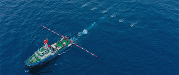
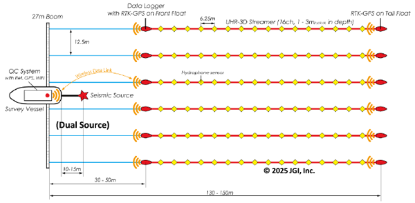
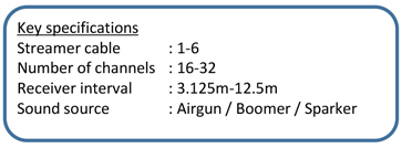
The Ultra High Resolution Seismic (UHRS) uses a data acquisition and processing system developed in-house. UHRS targets relatively shallow areas under the seabed and can be operated on a small vessel of the 20-300 ton class, so that it can obtain a high-resolution 3D image at a lower cost than a standard 3D survey that targets deep. In addition, by operating two types of seismic sources with different output frequency bands at the same time (dual source operation), it is also possible to acquire subsurface structure data with variable resolution from a few meters below the seabed to several hundred meters.
Using the UHRS system for 3D seismic exploration (UHR-3D) in shallow waters, we help accurately identify geological risks such as faults, shallow gas, and soft layers. This is achieved by three-dimensionally visualizing geological stratigraphy, which is then compared to the support layer and engineering basement crucial for the design of structures.
![[UHR-3D 3D processing results and examples of in-line and cross-line cross sections]](https://jgi-inc.com/en/wp-content/themes/originaltheme/asset/img/technology/seismic-survey-service/cross-section-02.png)
(Teranishi et al., 2020, the 143rd SEGJ conference)