Marine Electromagnetic Survey

Marine Electromagnetic Survey
Marine electromagnetic survey is an exploration method that measures the resistivity of subsurface formations by transmitting alternating current in seawater and detecting the electric and magnetic fields induced within the geological strata using receivers deployed in the ocean. The resistivity values of rocks vary significantly depending on the type of fluid that fills the pores between mineral grains. If the pores are saturated with saline water, which is a good conductor of electricity, the resistivity decreases; conversely, if they are filled with non-conductive hydrocarbons, the resistivity increases. In other words, areas exhibiting high resistivity values may indicate the presence of hydrocarbons. Seismic exploration, which is commonly employed in hydrocarbon exploration, is highly responsive to strata containing hydrocarbons and effectively indicates their presence or absence, but it cannot determine the quantity. Marine electromagnetic surveys are regarded as a promising method to estimate the presence and quantity of hydrocarbons (see Figure 1).
![[Figure 1 Gas saturation and intensity of response by exploration method]](https://jgi-inc.com/en/wp-content/themes/originaltheme/asset/img/r-and-d/electromagnetic-survey/01-01.png)
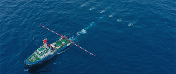
Currently, offshore marine electromagnetic survey services are not available domestically. We are working in collaboration with research institutions and universities to domestically develop marine electromagnetic survey technology, aiming to provide affordable survey services (see Figure 2). In 2020, we confirmed an integrated technology package for data acquisition, processing, and analysis through a demonstration survey in Japan’s offshore areas (see Figures 3 and 4). Currently, we are preparing for the near-future commercialization of this technology.
![[Figure 2 Elemental technology of marine electromagnetic survey exploration developed in joint research.]](https://jgi-inc.com/en/wp-content/themes/originaltheme/asset/img/r-and-d/electromagnetic-survey/01-02.png)
![[Figure 3 Results (right) of applying compound type noise suppression to real data (left)]](https://jgi-inc.com/en/wp-content/themes/originaltheme/asset/img/r-and-d/electromagnetic-survey/02-01.png)
(Takai et al., 2022, Journal of the Petroleum Technology Association)
![[Figure 4 Marine electromagnetic survey layer (color)]](https://jgi-inc.com/en/wp-content/themes/originaltheme/asset/img/r-and-d/electromagnetic-survey/02-02.png)
(Modified from Takai et al., 2022, Journal of the Petroleum Technology Association)